Wednesday, April 3, 2024

How to build your own observatory to watch the solar eclipse

Solar eclipse sunglasses are becoming a hot commodity as we get closer to August 21. If you are not able to find a pair of the special glasses, you can still watch the eclipse with your own eyes. How? Build your own solar observatory with a few household items. Plus, it is perfectly safe for your eyes!

Kids, ask your parents for help building this observatory!


WHAT YOU NEED:

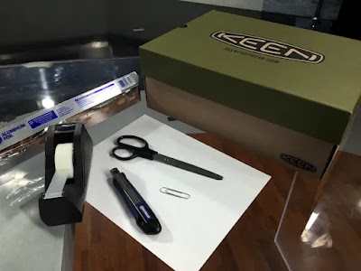
  • Shoe box
  • 1 piece of white paper (can be a half sheet)
  • Utility knife or X-Acto blade
  • Tape
  • Pin or paperclip
  • Small piece of aluminum foil


HOW TO ASSEMBLE

1. Cut a square hole approximately 1″ by 1″ in the lower right small end of the shoe box using the utility knife.

Hint: If the shoe box has a cut-out in the lid, cut the 1″x1″ hole at the other end of the box.

2. Cut a piece of aluminum foil that is slightly larger than the 1″x1″ hole from step 1. Place the piece of aluminum foil over the hole and tape it to the box. Be sure to only place tape on the outside edges of the foil.

3. Use the pin or paper clip and gently make a pin hole in the center of the aluminum foil. The hole is where the sun will shine through.

Hint: If you are using a piece of thin aluminum foil, before taping the foil to the box place the it on a table top. Gently press the pin or paperclip against the foil until a small hole is made. Then tape it to the box. If the foil tears while poking a hole in it (similar to what you see in the picture), you can fix it by taking another piece of foil, put a small hole in it, then tape the second piece over the first piece making sure to line up the holes so light can shine through.

4. Tape the white paper to the inside of the box directly across from the square of aluminum foil with the pinhole. The piece of paper will act as a movie screen for your observer. This is where the sun’s image will appear.

5. Using the utility knife, cut another 1″x1″ hole in the lower right corner of the long side of the box. This will be the hole you look through. You will be able to see the white paper you taped to the inside of the box through this hole.

6. Stand with your back to the sun, close the lid and look through the open square on to the white paper. Adjust the box so you can see the sunlight through the pinhole and on the white paper.

You will see a small image of the sun projected on the white paper.

Tuesday, January 24, 2023

Mid-week Snow Coming to Central Indiana

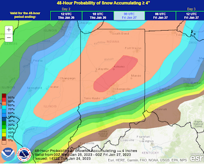
We're just about 12 hours from snow arriving in central Indiana. The updated forecast from NOAA NWS Weather Prediction Center suggests there is anywhere from a 50% to 95% probability for a 4" or greater snow in central Indiana.

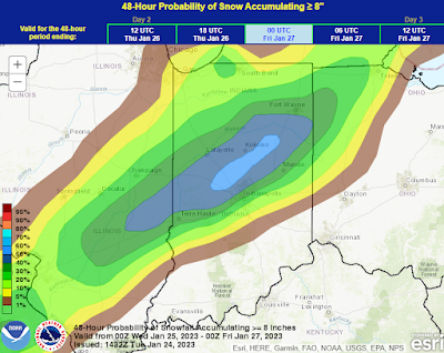
When looking at an 8" or greater snow they include a large portion of central Indiana in a 40% to 60% probability just north of I-70 and I-69.

The latest 131-computer model average suggests the following for locales in Indiana.

Indianapolis: 7.1" | Range: 4.3" to 9.8"
Columbus: 5.4" | Range: 1.6" to 8"
Lafayette: 5.1" | Range: 3.9" to 6.5"

A note about the type of snow that will fall Wednesday. It will be a heavier wet snow than what has fallen previously this winter. Snow to water ratio's of 8:1 to 10:1. That means it will be a good packing snow (snowballs/snowmen) but also means this is more of a "heart attack" snow. Be careful when out shoveling!

How much snow would you like to see Wednesday?

Wednesday, December 14, 2022

Prospects of a White Christmas in central Indiana this year

A lot of people starting to ask about the prospects of a White Christmas in central Indiana.

Meteorologists define "White Christmas" as having 1" of snow on the ground at 7am December 25.  Historically, Indianapolis has had a White Christmas 28% of the years since 1899.  The last White Christmas was 2017 and the city has only had it two out of the last 17 years.  So you could say we are overdue for snow Christmas morning.

Let me just say that it too early to say with any certainty if there will, or won't be, snow on the ground for Christmas.  Considering it takes just a few hundredths of an inch of liquid to produce 1" of snow (when it is very cold), it is impossible to forecast this far in advance.

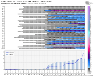
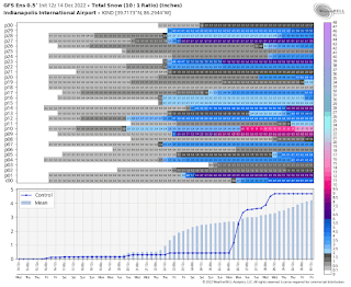
That being said, I have taken a closer look at the long range global computer model ensembles.  Specifically, the ECMWF, GFS, and the CMC.

If you don't know, computer model ensembles are a combination of computer model runs.  Instead of running just a single forecast, the computer model is run a number of times from slightly different starting conditions. The complete set of forecasts is referred to as the ensemble, and individual forecasts within it as ensemble members.

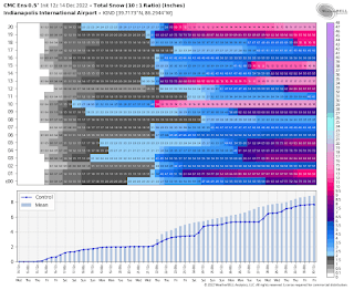
The three ensembles - ECMWF, GFS, and CMC - result in a total of 100 different forecasts, or ensemble members.  Out of the 100, 75 members suggest there will be at least 1" of snow on the ground 7am December 25.  It should be noted that is a 6.3% decrease from Tuesday night's runs.

The images show the various members of the ensembles.


Keep in mind this is just one instance of runs.  This is going to, and likely will, change every six hours as more data becomes available.

One thing that is looking more and more likely is a blast of cold air coming to the Midwest late next week.  For more on that, visit my FB page and scroll down to the previous post.

Let me know what you are hoping for Christmas.  A White Christmas or not.

Wednesday, August 24, 2022

Turning the Page

DID YOU KNOW: You know I like to come up with interesting stats, so here are a couple for you.
4,799 and 1,404

These are the number of forecasts (4,799) and newscasts (1,404) I will have appeared on Channel 8 News (KLKN-TV) through August 30. I mention the numbers because August 30 will be my last day at KLKN-TV.


This decision did not come hastily. I have been contemplating it for over a year and made the decision at the beginning of the year.

I have thoroughly enjoyed working evenings with Rod Fowler and Megan Conway and most recently in the mornings with Andrew Ward and Katrina Sperl. I have also enjoyed working with the talented team of meteorologists amassed during my time at the station.

I had several goals I wanted to accomplish when arriving at the station in August 2020.
  • First and foremost, keep viewers safe and informed when it comes to the weather. And maybe the viewer will learn a few things about weather along the way.
  • Secondly, bring professionalism to the weather department.
  • Third, build trust with our viewers. (And hopefully gain viewers along the way.) I wanted viewers to know they could tune in during severe weather coverage or on “normal” days and know they could get a straightforward forecast without hype.
I like to think those were met and accomplished.

Finally, I want to thank everyone in Nebraska for welcoming me into their homes and always saying hello when meeting me out and about. Also, thank you for not getting too angry with me when I had to cut-in to programming, wiping out your television shows. Just know, I did it to try to keep every person – regardless of what city they reside – safe.

Additionally, after nearly 23 years, now is the right time for me to get out of the tv weather business.

This does not mean you could not see me filling in a time or two at a station in the future because I still have a love of weather. And I will continue to post weather information on Twitter (@JohnDissauer), Facebook (/DissauerWx) and here on my blog.

What’s next… I am now looking for new career opportunities outside of the television and weather business. (If you know of any opportunities you think would be a good fit, send me a message!)

Tuesday, June 23, 2020

Saharan dust getting closer to the United States

By now you have probably heard talk about a cloud of dust moving across the Atlantic Ocean that originated from the Saharan Desert in Africa.  The large area of dust is just about to reach the Gulf of Mexico.

(Click image to see larger version)
This is a visible satellite loop over the last 6-hours this morning, ending at 10:50am EDT.  If you look towards the Caribbean you can see the brown colored cloud.  That's the dust!  Look at how far it stretches from nearly the Gulf of Mexico all the way off the screen.  Thousands and thousands of miles.


The dust will help inhibit tropical storm development over the Gulf of Mexico.

NASA computer models project some of the dust could make it to the Midwest as we get towards the end of the week and in to the weekend.  That could make for some very pretty sunrises and sunsets.

For more on the dust layer and tracking it by satellite, check out this page from the Cooperative Institute for Meteorological Satellite Studies at the University of Wisconsin.

Thursday, June 18, 2020

Parts of Indiana register in Drought Monitor

The latest Drought Monitor classifies 70.5% of Indiana as D0 (Abnormally Dry).
(Click image to see a larger version.)
A lack of rain since June 5 is starting to show when looking at lawns around central Indiana.  What was once green grass is now turning brown.  Look under the grass and you can see soil drying out.

This ties for the driest June 5 through June 18 since 1871 in Indianapolis - tying 2012 - with only a trace of rain recorded.

Amazingly, Indianapolis has lost 31% of its annual precipitation surplus in 14 days.  Indy was well ahead of normal as of June 4.  The city was 5.70" above normal.  Today, June 18, the surplus has dropped to 3.89".


A 2-computer model average suggests 1.19" of rain falling through the next seven days.  That equates to 117% the normal for the period.

A couple things to keep in mind:
  1. We are currently losing approximately 0.25" of water from the ground daily from evaporation.  So to keep "even", we need 1" of rain every 4 days.
  2. "Dry breads dry."  When dry conditions begin to set in, it is hard to break.  Often times in this situation computer models will start putting in precipitation 5-7 days out, but as we get closer to those days the models back off on the precipitation.  That is the case with with the above numbers.  The computer models start to introduce rainfall starting Tuesday, 5 days out.
What does this all mean?  If you want to have green grass, or revive your brown, it is time to start watering.  I wouldn't count on Mother Nature to do it for you anytime soon.

Tuesday, June 16, 2020

Lack of rainfall in the Midwest

Taking a closer look at regional precipitation data.  It is easy to see the have's and have not's, as well as the path Cristobal took through Arkansas, Missouri, Iowa, and Wisconsin.


The map shows the percentage of the normal accumulated precipitation from June 5-15.  Parts of Indiana and Illinois are running 5%-10% the normal rainfall according to data from Midwestern Regional Climate Center.  Some locations are even 0%.  Example: Indianapolis has only had a trace of precipitation for the period.

Are you noticing things turning brown in your neck of the woods?

Driest on record and not much relief in sight

If you look around central Indiana you'll notice lawns starting to turn brown.  That is because we have fallen in to a dry stretch as suggested last week.

Indianapolis has only measured a trace of precipitation since June 5.  This makes this the driest June 5 through June 16 since 2012.  This also ties for the record driest June 5-16 on record.  Records in Indianapolis started in 1871.

This has also putting a hit on the annual precipitation surplus.  Last week we were nearing 5" above normal.  Through the end of today - we are not expecting any precipitation today - the surplus has dropped to 4.17"


Those looking for help from Mother Nature won't find any.  Long range computer models suggest 0.49" of rain in Indianapolis over the next seven days.  That is only 49% the normal rainfall.  Combine that with the area losing about 0.25" of moisture from the ground due to evaporation, expect lawns to quickly turn brown.

If you haven't already, it is time to pull out sprinklers.