A quick update regarding today's chances of severe weather across southeast Missouri, southern Illinois, western Kentucky, northwest Tennessee, and northeast Arkansas.
As of 9am, there is a Tornado Watch just to the northwest of the listed above area. Here is a radar/watch composite graphic from 9:05am.
Most likely a watch will be issued that will cover parts of southeast Missouri and Southern Illinois in the next couple of hours.
The Storm Prediction Center (SPC) has upgraded parts of the area to a "Moderate Risk" while the remaining area is under a "Slight Risk". See graphic below.
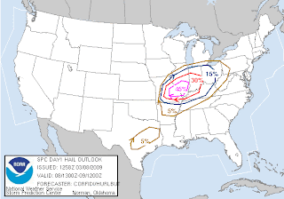
Here are some of the probability products SPC puts out concerning what types of severe weather could be seen.
Here is the large hail product.
Here is the high wind product.
Here is the tornado product.
As you can see, the biggest threat appears to be large hail and damaging winds from storms as they move through.
SPC's next outlook will be issued around 11:30am CT.
The National Weather Service in Paducah, KY has scheduled a conference call for emergency managers and tv meterorologists this morning. They typically do this when a "Moderate Risk" is covering part of their forecast area.


No comments:
Post a Comment