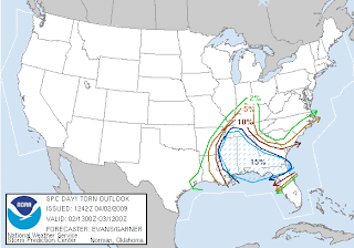
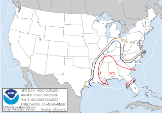
There could be some big storms across parts of the US today. The majority of the big storms should stay south of the "Heartland" (southeast Missouri, southern Illinois, western Kentucky). However, a few of these big storms could be close. Perhaps as close as Dyersburg, TN and south.
The SPC has the "Heartland" under a "Slight Risk". There is a huge "Moderate Risk" area generally from west Tennessee and south to the Gulf Coast. See the day 1 outlook issued at 7:30am below. The day 1 outlook covers the time period through 7am Friday.
Here is the tornado threat:
Here is the hail threat:
Here is the damaging wind threat:
If we see any severe storms, it should happen sometime from 12pm-5pm this afternoon. I think the main threat around here will be large hail and damaging wind. It isn't out of the question for a tornado to spin up around here due to the surface low passing over the top of us. (The surface low generates a lot of spin to begin with.)
One thing that could limit the amount of severe thunderstorms around here is the amount of moisture to work with. At 10am, temperatures range from the upper 50's to lower 60's in the area. Dew points are only in the upper 30's to lower 40's. The dew points will need to really climb (mid 50's+) to sustain stronger thunderstorms. Dew points in Nashville, TN and Memphis, TN are currently sitting in the middle 50's.


No comments:
Post a Comment