Sunday, November 17, 2013

Storm Reports

At of this writing storms continue to push off to the east through Ohio, Michigan and Kentucky.  I am sure many more storm reports will come in through the night.

As of 7pm Eastern, there have been 77 reports of tornadoes.  296 reports of damaging wind.  40 reports of large hail.

Unfortunately, as now I know of at least four confirmed deaths.  Two in New Minden, Illinois where preliminary survey information puts the tornado at an EF4 with winds at least 166 mph.  There have also been two confirmed deaths in Brookport, Illinois where it appears a tornado passed through the town.

Preliminary information is also coming in from the hard hit town of Washington, Illinois.  Preliminary survey information from the National Weather Service says that at least an EF4 tornado went through the town.  I have seen some reports that have described the town as "leveled with walking wounded".

When looking at the above map, it appears that several of the tornadoes may have been caused by as little as 5 supercell thunderstorms.  One started around the Peoria, Illinois area and tracked northeast through Washington, Illinois and eventually to Chicago's south side.  Another started in Wayne/Stoddard County, Missouri and tracked due east producing tornado reports from Morley, Missouri to Brookport, Illinois and further east in to Kentucky.

National Weather Service survey crews will busy over the coming days to find out what indeed caused the deaths and destruction across much of the Midwest.

10:15am Weather Update: Severe Storms Likely

Just finished looking over data.  To be honest, it is starting to look bad for parts of Illinois and Indiana.  I'm not seeing any new information that says the threat for severe weather is diminishing.

Let me show you what this morning's run (12z) of the high resolution RPM computer model is projection.  What you will see is the model's projection of what the radar will look like through the day.  Please keep in mind, this is not reality, it is just a computer model projecting what could happen.

Here is a look at 1pm ET.

Note that the model is starting to fire up a line of thunderstorms over northwest Illinois.  Also note the individual discrete cells flaring up over central Indiana.  The discrete cells are very concerning during the early afternoon.  If a few discrete storms can get going, they very well could become supercellular and tornado producers.

Here is a look at 2pm ET.

The individual storms are moving northeast across Indiana.  Also, a line of storms is starting to become more organized from southern Wisconsin to St. Louis.  Further south, storms are beginning to develop over southeast Missouri.

What is concerning about this image is the indication of storms beginning to move in to the Chicago metro area.  At that same time, the Chicago Bears game will be in the middle of the second half.  Not good to have tens of thousands of fans in the stands with possible severe storms moving in.

Next is a look at 4pm ET.

The line is becoming better organized as it races to the east.  While there is a line, it is interesting to note that the RPM is trying to suggest we are still looking at more of individual cells along a line instead of all the storms congealing in to one line.  This is not a good thing.  This indicates to me that the potential for tornado development is still very high.  Several strong tornadoes would be possible along this line of storms.

Here is a look at 5pm ET.

Strong to severe storms are now beginning to move in to Central Indiana.  At this point, forecast data suggests storms will be moving east-northeast at 65mph.  These storms will still have the potential to produce strong tornadoes.

Storms are also starting to get stronger towards southern Illinois.

Here is a look at 7pm ET.

The line is now crossing the Indiana/Ohio border and storms are still racing east-northeast at 65mph.  The model also suggests the storms are moving through Columbus, Indiana and approaching the Louisville metro area at this time.

FREAK-OUT-METER:

Moisture is streaming north on southerly winds.  As of 10am ET, dew points were already in the 60°s in Illinois as far north as Chicago.  In Indianapolis the dew point was 59°.  By the afternoon the dew points should be well in to the 60°s for Indiana.  The moisture will act as gasoline for the storms to thrive off.

Unfortunately, it does look like a tornado outbreak is likely over Illinois and Indiana.  Hopefully not, but there are too many signs pointing to it today.  Along with tornadoes, damaging winds will be a HUGE threat from thunderstorms.

INDIANA:
  • Central Indiana: 8
  • Northern Indiana: 8
  • Southern Indiana: 6 -- (Columbus: 7)
ILLINOIS:
  • Central Illinois: 7
  • Eastern Illinois: 8
  • Northern Illinois: 7
  • Southern Illinois: 5
KENTUCKY: 
  • Western Kentucky: 4
  • Northern Kentucky: 5
MISSOURI:
  • Southeast Missouri: 4
  • St. Louis Metro: 4
OHIO:
  • Western Ohio: 6

High Risk Expanded

The Storm Prediction Center has expanded the "High Risk" area for severe storms today/tonight.  The area now includes nearly all of Indiana, much of Illinois, southern Wisconsin, southern Michigan and Western Ohio.

The outlook above is valid through 7am ET Monday.

The BIG concern for today is damaging winds and tornadoes.  The tornado threat is highest in the high risk area.

There is a large population base that lives within the risk areas today.  67-million live in a threat area.  Almost 19-million live within the high risk.

Take today seriously.  If a warning is issued for your location, seek shelter IMMEDIATELY.

Reminder... Follow me on Twitter (@johndissauer) as I will be sending out more real-time updates through that medium this afternoon/evening.

Late Night Data Update: Severe Weather Sunday

Plenty to talk about after looking over the late night computer model data.  We'll discuss timing of storms, what types of severe weather, and an updated Freak-Out-Meter.

COMPUTER MODEL DATA: 

I just looked over the late night computer model run and wanted to give you some idea what the latest high resolution computer models are projecting for Sunday's possible severe weather outbreak.

First, here is a look at the 4km RPM model from the midnight run.  This is looking at the model's projection of what radar imagery will look like at 3pm ET.

At this point the model is suggesting scattered thunderstorms are developing and trying to become more organized in to a line.  Notice the location of the storm clusters.  One up around the Chicago metro area and then it stretches down to southern Illinois and in to southeast Missouri.

One concern with this data... The Chicago Bears are hosting the Baltimore Ravens.  At 3pm ET, the game would likely be in the middle of the second half.  Having tens of thousands of spectators in the stands while severe thunderstorms are moving by is not the best thing.  It will be interesting to see how the NFL handles things tomorrow.

Now we move ahead two hours to 5pm ET.

You can see the line is moving through central Indiana at this point.  A couple things to note.  First, notice the "stronger" looking storms over northern Indiana.  I think that is definitely a possibility.  Also notice the lack of storms from Indianapolis down to Bloomington, IN.  Not sure what to make of that.  Perhaps the model is picking up on something.  That said, don't let your guard down in central Indiana.

Now we skip ahead to 7pm ET.

At this point the model has the line of storms crossing the Indiana/Ohio state line.  Still some very strong, and likely severe, storms moving east.  If this works out to be true, I have a feeling many people in Indiana will be going outside to start cleaning up from the mess left from the storms.

The next two animations are from other high resolution 4km computer models.  They are both running off the WRF model, but they both have different flavors.  One is called the ARW and the other is the NMM.  These animations are courtesy of the people at WxBell.

ARW:

Note that with this model, instead of bringing the bulk of the storms through in one line, it develops two lines of storms.  My guess is the model tries to develop thunderstorms early ahead of the cold front and pushes those east.  Then behind that line, along the cold front, it tries to develop another thin line of thunderstorms.

NMM:

The NMM keeps it similar to the RPM with having one line of storms coming through.

STORM TYPE PROBABILITIES:

Hopefully by now you have seen the latest from the Storm Prediction Center.  A "High Risk" is in place for parts of Illinois and Indiana which includes the cities of Indianapolis, Bloomington (IN), Lafayette, Terre Haute and Champaign (IL).

All along the main threats for storms Sunday have been damaging wind and tornadoes.  Now that we are getting closer to the event we can start breaking the threat down more by probabilities.  Here is the Storm Prediction Center's probability forecast for damaging wind.

SPC indicates there is a 45% probability of severe winds for a large part of the Midwest.  The hatched area indicates a 10% or greater probability of wind gusts in excess of 75 mph.

Here is a look at SPC's probability forecast for tornadoes.

In the "High Risk" area they indicate a 30% probability of a tornado.  Perhaps more importantly, look at the hatched area.  It covers a very large area from Cairo, IL to Toledo, OH.  The hatched area means a 10% or greater probability of an EF2-EF5 tornado happening within 25 miles of any point within the area.

That is significant and echos the threat tornadoes will be Sunday.  It doesn't mean there will be a tornado, but it tells me that there is a chance for one, or a few, strong tornadoes.

FREAK-OUT-METER:

Central Indiana: 6
Northern Indiana: 7
Southern Indiana: 4 -- (Columbus: 5.5)

Central Illinois: 5
Eastern Illinois: 6
Northern Illinois: 5
Southern Illinois: 5

Western Kentucky: 4
Northern Kentucky: 4

Southeast Missouri: 4
St. Louis Metro: 4

High Risk - Severe Weather Update

The Storm Prediction Center has placed parts of Indiana and Illinois in a "High Risk". This is only the 5th time a High Risk has been issued in November and is the first since 2005. It is indeed rare.

A "Moderate Risk" includes Illinois, Kentucky, Michigan, Ohio and Wisconsin. Outside of there is a "Slight Risk".  The outlook covers from 7am ET Sunday through 7am ET Monday.

The main threat will be damaging winds and tornadoes. A severe weather outbreak looks likely across parts of the areas.

Please look at previous posts for timing of when storms can be expected in various areas.
This is a potentially dangerous situation for some areas. Also at risk, two NFL games will be taking place in Chicago and Cincinnati. Stay tuned...

- Posted from my iPhone

Saturday, November 16, 2013

Forecast Animation: Severe Weather in Indiana

Here is a look at a animation of the afternoon run of the high resolution 4km RPM computer model.  The model is projecting what the radar will look like Saturday night through Sunday afternoon.  It is also projecting what satellite imagery will look like (cloud cover).  Keep in mind the time listed in the animation is listed in Mountain Time not Central or Eastern.


Keep in mind this is only a computer model projection and not reality.


Forecast Animation: Severe Weather in Midwest

Here is a closer look at what the afternoon run of the high resolution 4km RPM forecast model is projecting for Sunday in the Midwest.

What you are looking at is what the computer model is projecting the radar will look like.  Along with the radar, it is also projecting what satellite imagery will look like (clouds).


Keep in mind this is just a computer model.  It is not reality.  But hopefully it gives you some idea of what you can expect Sunday.


Sunday Severe Weather Outbreak - UPDATE

Wanted to give a quick update concerning what some of the latest computer model runs are showing.  I was able to run in to the station and grab off a couple of "cleaner" images of what the high resolution 4km RPM is suggesting for Sunday's weather in the Midwest.

First of all, the Storm Prediction Center is still indicating there is a threat for severe weather across much of the Midwest Wednesday.  Here is the latest outlook from the SPC.

Orange indicates a "Moderate Risk".  Yellow indicates a "Slight Risk".  As you can see from the map above, many large metropolitan areas are included in the "Moderate Risk".

The next couple images are going to be from the afternoon (18z) run of the RPM computer model.  What you are seeing is what the model is predicting the radar will look like along with satellite imagery.  The time on the graphic is shown in Mountain Time.  Add two hours for Eastern and one hour for Central.

As I mentioned in my previous blog post, there will likely be a few showers and thunderstorms developing overnight tonight in southeast Missouri, southern Illinois and southern Indiana.  The above image is for 2am MT or 4am ET.  Notice it does have a cluster of strong thunderstorms over southern Indiana.  This could produce heavy downpours, frequent lightning and gusty winds.

Next, we are looking at 11am MT or 1pm ET.

You can see that the model suggests the cluster of storms in Indiana have moved off to the east/southeast.  But now turn your attention back to the west from northern Illinois through the St. Louis metro and down through southern Missouri.  This is the list of storms I think will eventually become the "main show" for Sunday.

Initially the model suggests the line will get started with individual cells before eventually coming together as a line.

Now we are looking at 2pm MT or 4pm ET.  Notice the line is maturing and moving east going from southern Michigan through western Indiana through southern Illinois to southeast Missouri.  As I expected, the highest energy for the overall system will be a little further north.  Notice how much more organized the storms look in north central/west central Indiana versus southern Illinois and southeast Missouri.

Here is a closer look at central Indiana.  While the time stamp says 3pm MT it is actually 2pm MT or 4pm ET (my mistake).

At this point the storms are just west of Fort Wayne and moving through Lafayette and Terre Haute.  I still think a 5pm-8pm time frame is looking realistic for the Indianapolis metro area.  As for other timings, check out my previous blog.

I am in the process of uploading a couple of animated videos that will give you a better idea of what to expect from the RPM for tomorrow.

Also, my Freak-Out-Meter stays the same as I posted in my previous blog post.


Severe Storms Sunday

The threat for severe weather Sunday continues for parts of the Mississippi River Valley and the Ohio River Valley.

The Storm Prediction Center has placed parts of Illinois, Indiana, Kentucky, Michigan and Ohio in a "Moderate Risk" for severe storms.  They have also placed parts of Arkansas, Illinois, Iowa, Kentucky, Missouri and Tennessee in a "Slight Risk".  The outlook covers the time from 7am ET Sunday through 7am ET Monday.

The population bases within the different risks are pretty high.  Seventy-six and a half million people live within the risk area.  A little over 39-million people live within the "Moderate Risk" and another 37-million live within the "Slight Risk".

Hopefully, people aren't taken by surprise with the potential for severe weather.  November is not an unusual time for severe weather.  In fact, it is the height of the secondary severe weather season for Ohio River/Mississippi River Valleys.

Here is a look at the latest information from the RPM 4km high resolution computer model.

It suggests a line of storms begins to develop and quickly strengthen around 11am Sunday in northwest Illinois.  If this holds true, this could start to bring the line in to the St. Louis metro area shortly before noon.  It would also bring a line of storms near the Chicago metro area around noon.  The model also suggests the line of storms reaching central Indiana between 5pm and 8pm.

IF a line develops further south in to Missouri, the model is suggesting it could start to arrive in southeast Missouri around 12pm-1pm.  The line would continue to move east arriving at the Mississippi River (in southeast Missouri) around 2pm-3pm.

The line mentioned above is likely a secondary line that will develop ahead of a cold front.  Well ahead of the front there could be isolated to scattered thunderstorms later Saturday night through early Sunday morning (pre-dawn) in Missouri, Illinois, Indiana and Kentucky.  There is enough instability to generate a few strong thunderstorms but I think the "main show" will be the secondary line.

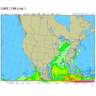
There appears to be plenty of instability within the atmosphere to get thunderstorms going.  Here is a look at the CAPE's (a form of instability forecasters look at) from this morning's run of the North American Model at 12pm CT.

CAPES are anywhere between 500 and 1000+ joules/kg for anywhere from Michigan down through Arkansas.

Also, if you step up to around 30,000 feet, there will be tremendous amounts of lift taking place due to divergence in the jet stream starting Sunday morning for areas west and southwest of St. Louis.  Then by late morning a powerhouse jet streak will start to nose in to central Illinois and western Indiana.  Winds will be moving along at 145mph out of the west at 30,000 feet.

Further down the atmospheric column winds will be coming out of the southwest at 55-70 mph just 5,000 feet above the ground.  This being the case, there will be lots of dynamic energy along with turning of the winds throughout the column.  Any thunderstorms that get going can start turning quickly.

I want you to note the probabilities put out by the Storm Prediction Center.

Notice the large 45% probability through the Midwest.  That doesn't mean there is a 45% chance of severe storms for that entire area, however it means that there is a 45% probability of severe weather occurring within 25 miles of any point within that area.

You may also notice the hatched area.  That indicates an area where there is a 10% or greater probability
of significant severe weather within 25 miles of a point.

So what are the main threats?  Right now, it appears that the biggest threat from thunderstorms will be strong, damaging winds.  Also, I think there is a decent tornado threat with this setup.  Especially the further north you go.  For right now, lets say north of I-64 in Illinois in to Indiana.  That means there will be a threat for tornadoes in central/northern Illinois, most of Indiana, southern Michigan and perhaps Ohio.

Since this is a time of year when people aren't thinking about severe weather, make sure you have fresh batteries in your NOAA Weather Radio.  Go over your action place with your family.  What are you going to do/where are you going to go if a Tornado Warning or a Severe Thunderstorm Warning is issued?

FREAK-OUT-METER

Finally, a lot of you ask about my "Freak-Out-Meter".  What is the meter?  It is basically a way for me to try to indicate how much I am concerned about the storm.  Hopefully, for some of you that get freaked out easily from weather it is a way to calm your nerves but also a way for you to see how big of a deal this is.  Keep in mind, this is on a scale from 0-10 with zero meaning I'm not concerned to a 10 meaning I'm beyond concerned.

Central Indiana: 6
Southern Indiana: 5
Northern Illinois: 6
Central Illinois: 5
Southern Illinois: 4
Northern Kentucky: 4
Western Kentucky: 4
Southeast Missouri: 4
St. Louis Metro: 4

Thursday, November 7, 2013

Super Typhoon Haiyan

You may hear about a super typhoon on the news tonight and tomorrow.  In fact, you may hear about a super typhoon in the news for quite some time.  The super typhoon I am referring to is Haiyan.  The reason you may hear about the storm for a while is because of the damage this storm will likely cause to southeast Asia.

Here is a visible satellite image of Super Typhoon Hiayan prior to landfall in the Philippines from Thursday afternoon.

The storm is very impressive.  Here are a few factoids about the storm.
  • Super Typhoon Haiyan had 195 mph sustained winds with gusts to 235 mph prior to Philippines landfall.
  • From a NOAA employeee: Super Typhoon Haiyan at 195mph (sustained winds) and wind gusts to 235mph is worse than Hurricane Andrew, on par with Hurricane Mitch and much worse than Hurricane Katrina.
  • Satellite estimates of Super Typhoon Haiyan's central barometric pressure is 25.34" (or 858mb).  If true, this would make the storm the earth's most intense on record.
  • Wave heights have been measured at 44-50 feet.
  • The same area being hit by the super typhoon experienced a 7.1-magnitude earthquake last month, killing 222 people.
The last forecast track I saw from the U.S. Navy suggests the storm will move back out over the South China Sea and the storm will make a second landfall in Vietnam in a couple of days.

As I saw someone say earlier... This is an international storm that will require international response.