Tuesday, June 23, 2020

Saharan dust getting closer to the United States

By now you have probably heard talk about a cloud of dust moving across the Atlantic Ocean that originated from the Saharan Desert in Africa.  The large area of dust is just about to reach the Gulf of Mexico.

(Click image to see larger version)
This is a visible satellite loop over the last 6-hours this morning, ending at 10:50am EDT.  If you look towards the Caribbean you can see the brown colored cloud.  That's the dust!  Look at how far it stretches from nearly the Gulf of Mexico all the way off the screen.  Thousands and thousands of miles.


The dust will help inhibit tropical storm development over the Gulf of Mexico.

NASA computer models project some of the dust could make it to the Midwest as we get towards the end of the week and in to the weekend.  That could make for some very pretty sunrises and sunsets.

For more on the dust layer and tracking it by satellite, check out this page from the Cooperative Institute for Meteorological Satellite Studies at the University of Wisconsin.

Thursday, June 18, 2020

Parts of Indiana register in Drought Monitor

The latest Drought Monitor classifies 70.5% of Indiana as D0 (Abnormally Dry).
(Click image to see a larger version.)
A lack of rain since June 5 is starting to show when looking at lawns around central Indiana.  What was once green grass is now turning brown.  Look under the grass and you can see soil drying out.

This ties for the driest June 5 through June 18 since 1871 in Indianapolis - tying 2012 - with only a trace of rain recorded.

Amazingly, Indianapolis has lost 31% of its annual precipitation surplus in 14 days.  Indy was well ahead of normal as of June 4.  The city was 5.70" above normal.  Today, June 18, the surplus has dropped to 3.89".


A 2-computer model average suggests 1.19" of rain falling through the next seven days.  That equates to 117% the normal for the period.

A couple things to keep in mind:
  1. We are currently losing approximately 0.25" of water from the ground daily from evaporation.  So to keep "even", we need 1" of rain every 4 days.
  2. "Dry breads dry."  When dry conditions begin to set in, it is hard to break.  Often times in this situation computer models will start putting in precipitation 5-7 days out, but as we get closer to those days the models back off on the precipitation.  That is the case with with the above numbers.  The computer models start to introduce rainfall starting Tuesday, 5 days out.
What does this all mean?  If you want to have green grass, or revive your brown, it is time to start watering.  I wouldn't count on Mother Nature to do it for you anytime soon.

Tuesday, June 16, 2020

Lack of rainfall in the Midwest

Taking a closer look at regional precipitation data.  It is easy to see the have's and have not's, as well as the path Cristobal took through Arkansas, Missouri, Iowa, and Wisconsin.


The map shows the percentage of the normal accumulated precipitation from June 5-15.  Parts of Indiana and Illinois are running 5%-10% the normal rainfall according to data from Midwestern Regional Climate Center.  Some locations are even 0%.  Example: Indianapolis has only had a trace of precipitation for the period.

Are you noticing things turning brown in your neck of the woods?

Driest on record and not much relief in sight

If you look around central Indiana you'll notice lawns starting to turn brown.  That is because we have fallen in to a dry stretch as suggested last week.

Indianapolis has only measured a trace of precipitation since June 5.  This makes this the driest June 5 through June 16 since 2012.  This also ties for the record driest June 5-16 on record.  Records in Indianapolis started in 1871.

This has also putting a hit on the annual precipitation surplus.  Last week we were nearing 5" above normal.  Through the end of today - we are not expecting any precipitation today - the surplus has dropped to 4.17"


Those looking for help from Mother Nature won't find any.  Long range computer models suggest 0.49" of rain in Indianapolis over the next seven days.  That is only 49% the normal rainfall.  Combine that with the area losing about 0.25" of moisture from the ground due to evaporation, expect lawns to quickly turn brown.

If you haven't already, it is time to pull out sprinklers.

Saturday, June 13, 2020

Refreshing air set to arrive later today

Humidity will begin to quickly drop once a backdoor cold front slides through central Indiana.

Dew point temperatures were in the middle 50°s Saturday morning.  They are forecast to drop in to the 40°s by late afternoon and evening.


Interesting to note that the HRRR (computer model) takes the dew point down to 31° in Indianapolis tonight. That would shatter the record low dew point for the date since 1942; 36° in 2012.

The record low dew point for the month of June is 24°. Two dates dropped that low. June 2, 1994 and June 22, 1974.

Thursday, June 11, 2020

This year's precipitation surplus likely to fall this week

Indianapolis is running a 4.84" precipitation surplus this year (through the end of today).


I'm not seeing much in the way of rain coming to central Indiana over the next week.  In fact, if you enjoy sunshine and low humidity you are going to like the weather through the weekend and next week.

A 2-computer model average for the next 7 days is only 0.005" in Indianapolis.  That is 0.96" below normal for the time period.

It is looking like a dry stretch is upon us and the next week could put a dent in the surplus.

What are conditions like where you live?

Wednesday, June 10, 2020

Severe thunderstorms possible Wednesday afternoon

It is a warm and humid morning around central Indiana.  The temperature only dropped to 79° overnight and dew point temperatures (measure of moisture in the atmosphere) remain in the 70°s.

As temperatures increase today instability in the atmosphere will increase, especially at the surface, in eastern Indiana and Ohio.

This is computer model projection of instability at 3pm EDT.


A cold front will begin to sweep through the Hoosier state during the early afternoon.  Behind the front, much drier air will begin arriving.  However, the front will provide lift at the surface, which in turn will aid in thunderstorm development.

A few thunderstorms have already developed in southwest Indiana.  Storms will continue to "pop" over the next couple hours in central Indiana. The storms will eventually evolve in to a line of thunderstorms while moving very quickly to the north/northeast towards the Indiana/Ohio state line.


Computer models suggest the line of thunderstorms reach the Indiana/Ohio state line between around 4pm EDT.

I think the highest threat for severe weather resides in Ohio and southeast Michigan. However, strong to severe thunderstorm are possible in the eastern third of Indiana.


The main threat from thunderstorms, especially once they develop in to a line, is damaging wind.  A few storms may be possible of producing hail and a few tornadoes cannot be ruled out, especially in northeast Indiana, Ohio, and southeast Michigan.

Tuesday, June 2, 2020

Increasing humidity taking heat index to highest levels of 2020

Say goodbye to low humidity. Southerly to southwesterly winds will help draw up low level moisture in the Hoosier state over the next 36 hours.

Dew point temperatures will climb through the 50°s today. It turns "muggly" Wednesday as dew points climb to around 70° - creating a heat index (the feel like temperature) in to the 90°s for the first time this year.

Saturday, May 30, 2020

SpaceX Crew Dragon second try at launching

SpaceX and NASA are going to give another try of launching two astronauts in to space this afternoon.  The launch is scheduled for 3:22pm EDT.

Similar to Wednesday I think this launch will probably not happen due to weather concerns.


As you can see in the above image, this high-resolution computer model suggests scattered showers and thunderstorms around Florida.  Looking at current radar, the storms have already developed, especially along the east coast of Florida.  If I were to put a number on it, I'd say there is a 30% chance of the launch happening.

LIVE COVERAGE OF THE SPACEX LAUNCH BY NASA:

Wednesday, May 27, 2020

Weather could play an impact in SpaceX Crew Dragon launch

Latest high-resolution data suggests there may be a window between 4pm-5pm for SpaceX's Demo-2 launch today. The launch is scheduled for 4:33pm EDT.


I think one of the main concerns will be convective development in the area.  That would include rain, turbulence, and lightning.  I don't know the meteorological minimums for the launch so it is hard to say with more confidence.

This launch is an important step for the United States space program.  It has been nearly 9 years since the United States launched a person in to space.  It was July 8, 2011, the final flight of NASA's Space Shuttle.

Another aspect to this being a big step is this will be the first time a person will go in to space on a commercial spacecraft.  Until now humans have only gone to space on the back of government space programs.

LIVE COVERAGE OF THE SPACEX LAUNCH BY NASA:


Additional coverage from various organizations:

Saturday, May 23, 2020

A few severe thunderstorms possible Saturday afternoon and evening

There is a chance a few thunderstorms could become severe this afternoon and evening, especially in northern Illinois.


I do not expect widespread severe weather but a few storms will have the capability of producing large hail.  Also, a few tornadoes cannot be ruled out, especially in northern Illinois.

While weather is not necessarily top of mind during the holiday weekend, keep an eye on the weather if you're going to be out later today.

Friday, May 22, 2020

Sweating weather is coming

Temperatures start a warming trend today and continue through Memorial Day Weekend.  We are going to go from the 50°s earlier this week to the mid-80°s Sunday.


As temperatures increase through the weekend, so do the dew points.  Right now it looks like the dew point temperature will climbs to the upper 60°s as early as Sunday and then stick around at that level through most of next week.  (A couple computer models even suggest the dew point could climb in to the low 70°s.)  That means our first taste of "muggly" weather is just a few days away.


What is "muggly" weather?  It is a term I have been using since the late 1990's.  I use it to describe what it feels like when it feels very oppressive.

Muggy + Ugly = Muggly

Anything above 60° feels uncomfortable.  Anything in the upper 60°s and 70°s becomes "muggly".

What do you think?  Are you ready for summer heat/humidity or are you fine with it staying cooler?

Wednesday, May 20, 2020

7-day outlook going in to Memorial Day Weekend

The latest outlook for central Indiana keeps the clouds and cooler temperatures around for at least another day.  BIG changes for the weekend!  Warmer temperatures & higher humidity.  Even had to include a heat index for Sunday/Monday.


Along with the warmer temperatures and humidity will be a daily chance for a shower/thunderstorm.  However, it will not be all day rain this weekend.

Real ID requirement extended

The Department of Homeland Security announced today that they are extending the Real ID requirement due to circumstances related to COVID-19.  The date is now October 1, 2021.


This is important for travelers as TSA will not be able to use your non-Real ID drivers license as a form of ID to pass through security at airports.

If you aren't familiar with Real ID, it is a new secure drivers license DHS is requiring states to implement.  In most states, it requires additional documentation when applying for a new drivers license or a renewal.  More about Real ID from DHS.

Sunday, May 17, 2020

Flash Flood Watch issued through Tuesday

Heavy rains are projected to impact central Indiana through early week.

The Weather Prediction Center - handles snow and rainfall forecasts for NOAA - has included portions of Indiana, Illinois, Ohio, and Kentucky in a "moderate" risk for excessive rainfall through Tuesday.


A 26-computer model average suggests the following rainfall amounts through 2pm EDT Tuesday.

Columbus, IN: 1.84"
Indianapolis, IN: 1.91"
Richmond, IN: 2.37"

To put the rainfall amounts in perspective... For Indianapolis, the amount forecast is 374% above the normal rainfall for the three day period (0.51").


The National Weather Service has issued a Flash Flood Watch that is in effect until 2pm EDT Tuesday for portions of central Indiana.

Elevated tornado threat Sunday

We will need to keep an eye on thunderstorms later today/this evening. Computer models suggest a line of t'storms entering Indiana around sunset.
HRRR computer model projection of radar imagery at 8pm EDT Sunday.
NAM computer model projection of radar imagery at 8pm EDT Sunday.
The latest data from the Storm Prediction Center suggests the atmospheric environment will be supportive of up to a 5% tornado probability in highlighted area from 3pm-9pm EDT Sunday.


While the threat is low, it is not zero.  Make sure you have a way to be alerted if/when severe weather alerts are issued from the National Weather Service.

Monday, May 11, 2020

Windiest in over seven decades

Wow it has been windy lately!  That was the case Sunday, May 10 in central Indiana.  Indianapolis alone had 13 consecutive hours with wind gusts 26+ mph.

  • 11pm: 26 mph
  • 10pm: 40 mph
  • 9pm: 35 mph
  • 8pm: 33 mph
  • 7pm: 32 mph
  • 6pm: 39 mph
  • 5pm: 32 mph
  • 4pm: 39 mph
  • 3pm: 40 mph
  • 2pm: 39 mph
  • 1pm: 33 mph
  • 12pm: 30 mph
  • 11am: 28 mph

Historically speaking it was the windiest (26+ mph gusts) May 10 since records started in 1942 according to the Midwestern Regional Climate Center.

NUMBER OF HOURS WITH 26+ MPH WIND GUSTS:

  1. 13 - 2020
  2. 8 - 1990
  3. 3 - 1995, 1990, 2017

Friday, May 1, 2020

The More You Kmow: The weekend opens dry

There are great mowing conditions this evening around central Indiana.  Temperatures will be in the low 60°s with sunshine.  Sunset is at 8:40 p.m. in Indianapolis.


  • Much of Saturday will be dry and warm.  Temperatures should top out around 80°.  There will be a chance for scattered showers and thunderstorms by evening along a weak front that looks to lay over north-central Indiana.  Areal coverage of rain will be relatively small, so much of central Indiana should remain dry for the evening.
  • Sunday morning has rain which may linger in to afternoon.
  • Monday will be dry with high pressure moving in overhead.
  • As has been the case for the last couple weeks computer models suggest rain returns Day 4 - in this case Tuesday.  And has also been the case computer models are in much disagreement as to timing.  Right now I'm going to keep Tuesday morning, midday, and evening as "yellow".

Wednesday, April 29, 2020

The More You Kmow: Best days to work in the yard end of week and weekend

Scattered showers will remain a possibility though the evening.  The rain should not be widespread over central Indiana.


  • Showers will be possible Thursday morning.  As an area of low pressure moves off to the east, a few lingering showers could remain, especially over eastern Indiana.  Heating of the day may spark a few more showers late afternoon.  So I'll keep it a "yellow".
  • High pressure will keep things dry Friday and Saturday.
  • It looks like we will have rain arrive Sunday but there remains some question as to when it gets here.  One medium-range computer model suggests rain starting Sunday morning and light rain continuing throughout the day.  Another medium-range computer model keeps things dry Sunday morning, scattered showers developing by afternoon, and widespread rain arriving by evening.

Windy this month; Closer look at the windiest month over last three decades

Earlier today I overheard someone talking about how windy it has been recently.  They were suggesting that it is a lot windier than they remember it being.  That conversation sent me in to the depths of weather records.


The data shows that in fact it has been a windy April.  April ranks as the #1 month number of hours with 20+ wind gusts.  April averages 95.5 hours with 20+ wind gusts on average since 1990.  This year April has had 157 hours with 20+ mph wind gusts through April 28.  That is a 64% increase in number of hours.  So yes, it has been a bit windier than usual.

In fact, it is the windiest April in 9 years.  2011 had 184 hours with 20+ mph wind gusts.  We may make a run on that when you factor in today (April 29) and Thursday.

Click image to see larger version.
April is quite a bit ahead of the #2 month, March.  It works out to around 25% more.  That is followed by January.
  1. April
  2. March
  3. January
  4. November
  5. February
  6. May
  7. October
  8. December
  9. June
  10. September
  11. July
  12. August

Allergy Tracker: Brief relief from tree and mold

Rain passing through central Indiana Wednesday morning has knocked down tree and mold allergens for the moment.  Both tree and mold levels are expected to increase later today.

The highest tree allergens later today will be oak, maple/box elder, alder, birch, willow, hickory, mulberry, and cottonwood.

Tuesday, April 28, 2020

The More You Kmow: Evening showers and rain next two days

Such a nice day in central Indiana.  Temperatures this afternoon have climbed in to the 70°s.  Winds are a bit gusty, out of the south-southwest up to 28 mph.

The rest of the afternoon will remain dry.  A couple high-resolution, short range computer models are suggesting a few showers popping up between 5 p.m. and 6 p.m.  This may be a little overdone.  That being said, I am going to keep a chance of a spotty shower in the forecast by evening.  By the way, sunset is 8:37 p.m. this evening.
Rain becomes widespread overnight as a line of decaying thunderstorms arrives in the Hoosier state.  Rain will likely linger through the morning and midday Wednesday.  I'm going to through a yellow - "at your own risk" for the evening as it does appear the rain will let up and become less widespread in coverage.  However, the grass will  be wet.
  • Thursday morning looks to  be wet.  Moisture will be present on the  backside of an area of low pressure, so showers will be likely.  The rain may let up and become more scattered by midday and evening.  It looks be to be windy, especially for the morning and midday.
  • Friday and Saturday look dry as high pressure moves overhead.


Monday, April 27, 2020

The More You Kmow: Nice today but couple chances for rain this week

Today is a great day to fire up the mower and get your yard mowed.  I'll be doing the same later this afternoon.  Do it before a few showers pass overnight.  A couple showers may linger Tuesday morning but should be out of central Indiana by midday.

  • Wednesday is going to be a "No Mow" day.  We should wake up to rain falling.  Showers should continue through the afternoon and evening.  It will also be windy.  Leave the mower in the garage or shed.
  • Computer models suggest rain could linger on the backside of an area of low pressure Thursday morning.  Rain should begin to taper off by mid-morning and be mainly out of the area by afternoon.  It will also be windy morning and afternoon.
  • High pressure builds in Friday keeping it dry.

Sunday, April 26, 2020

Bright lights reported across the sky Sunday night and there is an explanation

If you saw a line of bright lights in the sky over the Midwest tonight (around 10:10 EDT), there is an explanation. They are part of Elon Musk’s Starlink project.  Forbes wrote an article about it a few days ago.

While many people in the Midwest reported seeing the bright lights, I even got a message (with video) from someone in the Caribbean.
Space X launched its seventh Starlink mission Wednesday, April 22, 2020 which included a payload of 60 Starlink satellites.

The project is to place around 12,000 of small satellites in orbit around the planet when the project is completed.  The satellites will be used to provide high speed internet around the globe.

There are only 420 in orbit to date.  I suspect we will have many more sightings of bright objects in the sky once the other 11,580 are placed in to orbit (approximately 350 miles above the Earth's surface).

Check out this video shot in Switzerland on April 24, 2020.  You can see the "train" of satellites crossing the sky.


Did you see the lights cross the sky?  Leave a comment and let me know.

The More You Kmow: Sunshine rest of today but more rain returns

It is a little gusty this afternoon but the sun is out!  Sunset isn't until 8:35pm so there are still a few hours to get outside.  Temperatures will be in the low 60°s in central Indiana.
  • Dry for most of Monday. Chance for a few showers late Monday north.
  • Morning showers Tue. A few sct Tue PM north along warm front.
  • Wet/windy Thursday.

Friday, April 24, 2020

Barometric pressure dropping and rain chances rising at Lake Monroe Saturday

If you are planning on going out on Lake Monroe Saturday pay attention to the forecast.  A few light showers possible around sunrise.  Temperatures climb in to the lower/mid 60° during the afternoon.  Rain arrives by late afternoon.

Anglers... The barometer will be dropping through the day.


The More You Kmow: Tracking chances for rain but there will be dry hours

There are going to  be many dry hours Saturday morning and afternoon afternoon to do yard work.  Southeasterly and easterly winds will due us a favor by helping keep the lower levels of the atmosphere dry.  As rain attempts to move in to central Indiana it will be delayed.  By late afternoon and evening there will be a chance for rain, but a few high resolution computer models suggest not everyone gets rain Saturday evening.

  • Showers linger Sunday morning in southern Indiana and perhaps in to the early afternoon in eastern/southeastern Indiana.
  • Monday looks mainly dry.  Models bring a front through the state Monday night but right now it looks like the rain will be contained to northern Indiana.
  • A few showers will  be possible Tuesday morning before drying out by midday.

Wet start to year looks to continue

Indianapolis has received 15.07" of precipitation this year through April 24.  That makes this the 30th wettest start to a year since 1872 in the Hoosier state capital.


It looks like above normal precipitation will continue for central Indiana.  Long range computer models suggest another 1.37" falling thru Friday, May 1. That works out to 142% the normal (0.96") for the time period.

Allergy Tracker: Relief for some tree pollen allergies

A slight air mass change has dropped tree pollen in the air over central Indiana today.  However, if you have a mold allergy, that will remain high throughout the day.


Tree pollen is projected to increase slightly this afternoon, peaking around 1 p.m.  The highest tree allergens will be oak, willow and maple/box elder.

Thursday, April 23, 2020

The More You Kmow: Tracking couple rounds of rain

Mowing is strongly discouraged this evening around central Indiana as rain continues to fall.  You will be much happier if you wait for Friday to work in your yard.


  • Rain arrives Saturday.  The morning should be fine for mowing.  Question remains regarding arrival of rain Saturday afternoon.  One computer model keeps a southeasterly/easterly wind which often holds the rain off several hours.  Another brings the rain in by late morning.
  • Showers hang around Sunday on the backside of an area of low pressure.  There could be a few showers lingering in to the early afternoon.
  • Dry Monday.

Allergy Tracker: Mold sufferers are likely feeling it today

With higher moisture content in the air due to rain it isn't too surprising to see mold is high now now around central Indiana. Mold levels are expected to increase this afternon.

Tree pollen levels are at moderate right now.  They are expected to increase to high this afternoon.  The highest levels of tree allergens right now are cottonwood, willow, birch, and pine.  This afternoon it is projected to include mulberry, maple/box elder, oak, elm, and elder.

Wednesday, April 22, 2020

Driest April in over a decade

It sure seems like we've had a lot of clouds and rain this month but data suggests a different story.

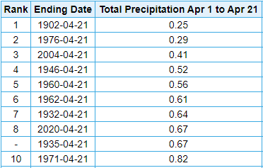
Over half the days this month have produced precipitation - 12 out of 21 days - officially in Indianapolis.  Twelve days produced rain and one day produced a trace of snow.only recorded 0.67" of precipitation this month.

Interestingly, the amount of rain for the month is relatively low.  Only 0.67" of precipitation has been measured which is quite low.  So low that this is the driest April (through the 21st) in 16 years in the Hoosier state capital.  This month ties for the 8th driest April (through the 21st) since 1871.
It looks like we will make-up for the dry start to the month with several chances for rain to close April.

Rain returns to Indiana Thursday morning, Saturday, Sunday, Tuesday, and next Wednesday.  Long range computer models suggest an additional 1.62" to 2.30" could fall through the end of the month.


Allergy Tracker: Tree and Mold allergens climb later today

The grass is green.  Trees are beginning to bud.  Flowers are beginning to show their colors.  'Tis the season for allergies to kick up.
The latest data shows tree and mold levels are low right now in central Indiana. They are expected to increase later today as winds shift around to the south/southwest.
Grass and weed remains in the clear today.

Tuesday, April 21, 2020

Rare air arrives in central Indiana

Dry air has arrived in central Indiana thanks to a cold front that has passed through the state. The dew point temperature in Indianapolis dropped to 20° officially at 1 p.m. (12:54 p.m. observation).  This is definitely more February-like air than late April.


This is extremely rare air.  So rare that this is the first time since 1942 the dew point has dropped to 20° or less between April 21-31 in Indy according to data collected from the Midwestern Regional Climate Center.

Friday, April 17, 2020

Wet start to the year and end of work week

It has been a damp, dreary, chilly day around central Indiana today.  Northern Indiana even received snow, with as much as 4" of snow reported, late Thursday night in to Friday morning.

Rainfall totals have been relatively light through 4pm.  Bloomington has picked up the most with 0.29".


For those of you thinking it has been a wet year you are correct.  Take a look at the numbers for Indianapolis.


Indianapolis has received 14.54" of precipitation for the year which is nearly 4" above normal. It currently ranks as the 24th wettest start to a year since 1872.

For those wanting drier conditions it appears there will be dry time coming over the next week.  Long range computer models are suggesting anywhere from a third to a half inch of rain possible through 8pm Friday, April 24 in Indianapolis.


Drier conditions start Saturday.  So if you need to get yard work done, Saturday is your day.  There will be a weak front passing the area Sunday.  That could bring a few widely scattered showers throughout the day.  Monday looks to remain dry.  Another front will pass through early Tuesday morning bringing with it a few light showers.

Thursday, April 16, 2020

Coldest temperature for date in 145 years

A second consecutive day with temperatures dropping in to the lower 20°s around central Indiana.  It got down as low as 22° just north of Zionsville!

DID YOU KNOW: This was the coldest temperature for April 16 in Indianapolis since 1875 (it dropped to 21°) - ranking the second coldest for the date on record (since 1871).

ADDITIONALLY... This morning was the coldest temperature in #Indianapolis since March 7.


Chance for accumulating snow quickly declining

Lots of talk of snow tonight/Friday for central Indiana but there is light at the end of the tunnel.  Historically speaking, the chances for an accumulating snow is quickly dwindling for the Hoosier state capital.

DID YOU KNOW: Since 1931 only 8 days have recorded measurable snow in Indianapolis from this date thru the end of May.


Friday, March 27, 2020

Severe weather threat ramps up Friday night through Sunday morning

An area of low pressure is going to move out of the Rocky Mountains Friday evening.  Ahead of the low, several front will be passing through the Midwest providing areas of lift and shifting winds.


Scattered thunderstorms are expected to develop along a warm front that will lift through Indiana Friday night in to Saturday morning.  Along and ahead of the front some of the thunderstorms will have the capability of producing hail.
Computer model projection of radar imagery at 1 a.m. Saturday EDT.
Some data suggests there could be a period of time when ingredients in the atmosphere could allow thunderstorms to spin along the front.  The greatest threat for this appears to be between 10pm EDT Friday and 3am EDT Saturday and primarily confined to a corridor between southwest Indiana to Columbia, Missouri.

It should start to feel more "stormy" Saturday in the Midwest.  Temperatures will be higher with temperatures in the 60°s and 70°s.  It is also going to be much more humid as dew points climb to the upper 60°s.  This will all happen before a cold front passes through Missouri, Illinois and Indiana Saturday evening through Sunday morning.


While there could be scattered showers and thunderstorms late Saturday morning, there will be many dry hours.

Thunderstorms should begin to develop in eastern Iowa and eastern Missouri early Saturday afternoon as the cold front begins to move through central Iowa and central Missouri.  Because of the atmospheric environment the thunderstorms could rapidly intensify.
Computer model projection of radar imagery at 8 p.m. Saturday EDT.
A line of thunderstorms is projected to be moving east through western Illinois shortly after sunset.  The line will continue to move east through Indiana late Saturday night through early Sunday morning.

Early in the afternoon the greatest threat will be damaging wind and tornadoes in southeast Iowa and northwest Illinois, roughly from Cedar Rapids, Iowa to Galesburg, Illinois.  As the line of thunderstorms moves east the threat will be primarily damaging wind, but tornadoes and hail will be possible.  The tornado and hail threat should begin to diminish through the overnight as the line of storms moves east through Indiana and in to Ohio.

I again suggest making sure you have working batteries in your NOAA weather radios.  Also, be sure to keep your phones charged, especially Saturday evening in case there are power outages.  Some high resolution computer model data suggests there could be power outages in Indiana late Saturday night through Sunday morning.